
No Easy Ground
The Battle at Robert’s Ridge

At more than 10,000 feet above sea level, Takur Ghar was an unforgiving place to fight.
The mountain rose above Afghanistan’s Shah-i-Khot Valley as part of a landscape shaped almost entirely by elevation. Sharp ridgelines enclosed the basin below. Gullies cut through the slopes. Exposed rock broke through deep winter snow, while caves and depressions offered natural concealment across the surrounding high ground. Roads were scarce, flat ground was even scarcer, and the higher a person climbed, the thinner the air became.
In early March 2002, winter still held the upper elevations. Snow covered much of the mountain and in places reached several feet deep. Temperatures remained cold enough that exposure would become increasingly dangerous as the hours passed, and conditions at altitude could shift quickly. What looked like a short distance from above could require hours to cross once boots were on the ground.
For the men moving through it, every feature of the landscape carried a consequence.
A steep slope slowed movement. Deep snow pulled at each step. Loose and uneven ground complicated footing. Elevation made the body work harder for less oxygen. A soldier climbing Takur Ghar did so beneath the additional weight of body armor, ammunition, weapons, radios, medical equipment, water, and whatever else the mission required. Even before enemy fire entered the equation, simply moving across the mountain demanded effort.

On the morning of March 4, 2002, Takur Ghar would become the center of one of the fiercest special operations battles of the early war in Afghanistan.
Navy SEALs, Air Force combat controllers and pararescuemen, Army Night Stalkers, and Rangers from the 75th Ranger Regiment would all be pulled into a fight that began as a reconnaissance mission, became a rescue operation, and ultimately stretched into a roughly seventeen-hour struggle for control of the mountain.
Seven Americans would lose their lives there.
The battle became known as Roberts Ridge.
To understand what happened on Takur Ghar, however, it is not enough to understand who fought there. The mountain shaped nearly every decision that followed. It determined where aircraft could land, how quickly reinforcements could reach the summit, where enemy fighters could conceal themselves, how wounded men could be evacuated, and how much strength remained in a body after hours of fighting at altitude.
The landscape was not simply where the battle happened.
It helped determine how the battle unfolded.

The Shah-i-Khot Valley
The Battle of Takur Ghar took place during Operation Anaconda, a major coalition offensive launched in eastern Afghanistan in March 2002.
Less than six months had passed since the attacks of September 11. The Taliban government had fallen, but significant numbers of al-Qaeda fighters remained scattered throughout Afghanistan’s mountains and valleys. Intelligence indicated that a large concentration of enemy forces had gathered in the Shah-i-Khot Valley, a remote basin in Paktia Province near the Pakistani border.
Operation Anaconda was intended to close around them. American conventional forces, special operations teams, Afghan partners, and coalition airpower would surround the valley and prevent enemy fighters from escaping into the mountains.
Geography complicated that plan from the beginning.
The Shah-i-Khot was not an open plain surrounded by gentle hills. It was a high-altitude basin enclosed by rugged ridges that rose above the valley floor and created natural observation points over the terrain below. Snow covered many of the upper elevations. Narrow draws and gullies cut across the slopes. Caves, depressions, and fortified positions disappeared into the mountainsides, giving fighters familiar with the region places to hide from observation and protection from attack.
Movement was equally difficult. There were few roads capable of carrying forces quickly across the region, and much of the surrounding high ground had to be approached either by helicopter or on foot.
In terrain like this, the high ground carried enormous value.
One of the most commanding positions overlooking the valley was Takur Ghar.
Its summit rose above the surrounding battlefield and offered a wide view across the Shah-i-Khot. From there, a reconnaissance team could observe enemy movement, communicate what they saw, and help direct air strikes onto positions throughout the valley.
American planners wanted eyes on the summit.
What they did not fully understand was that al-Qaeda fighters had already reached the same conclusion about the mountain’s importance, and they were already there.

The First Landing
In the darkness before dawn on March 4, an MH-47E Chinook from the Army’s 160th Special Operations Aviation Regiment approached the summit of Takur Ghar. The helicopter carried a reconnaissance team that included Navy SEALs and Air Force combat controller Technical Sergeant John Chapman.
Below them, the mountain was difficult to read.
At night, snow and exposed rock blended into shifting shades beneath night-vision equipment. The summit offered little room for error. A helicopter approaching high ground in darkness already had to contend with altitude, uneven terrain, and the limited space available to put an aircraft down safely.
As the Chinook descended, small details began emerging from the landscape.
Tracks crossed the snow.
A donkey stood tethered near the summit.
The signs were ordinary enough on their own, but together they suggested something far more dangerous: the mountaintop was not empty.
Seconds later, enemy fire erupted.
Small-arms rounds tore into the Chinook from close range. A rocket-propelled grenade struck the aircraft, and the controlled descent instantly became a fight to escape the mountain.
During the violent withdrawal from the landing zone, Navy SEAL Petty Officer First Class Neil Roberts fell from the rear ramp and landed on the snow-covered summit below.
The helicopter could not remain overhead. Badly damaged, it pulled away from Takur Ghar and eventually made an emergency landing several miles from the mountain.
Roberts had been left behind.
In a matter of moments, the terrain that had been chosen as an observation point had become enemy-held ground with an American stranded on top of it.


Back to the Summit
Less than two hours later, the surviving members of Roberts’ team boarded another MH-47 and flew back toward Takur Ghar.
They knew now that the summit was dangerous. What they still did not know was the full strength of the enemy occupying it.
Again the helicopter approached the high ground, and again fire came from the mountain.
This time, the aircraft managed to put the team down.
Once on the ground, the geography compressed the battle. Rocky positions, changes in elevation, and prepared enemy fighting locations allowed combat to unfold at extremely close range. Technical Sergeant John Chapman advanced toward an enemy bunker while the rest of the team came under fire from multiple directions.
Chapman was hit. Other members of the reconnaissance team were wounded, and eventually the SEAL element began moving down the mountain, believing Chapman had been killed.
Their withdrawal introduced another reality of the terrain: going down did not necessarily mean going easily.
The slopes below Takur Ghar were steep and broken, covered in ice and irregular rock. Moving away from the summit meant descending through the same environment that had already made the mountaintop difficult to approach.
Years later, an extensive review of surveillance footage and other evidence concluded that Chapman had survived his initial wounds. Alone on Takur Ghar, he regained consciousness and continued fighting after his teammates had withdrawn. He would eventually be killed there and was posthumously awarded the Medal of Honor.
By then, the mountain had already changed the shape of the mission several times.
Roberts was missing. Chapman was down. Multiple Americans were wounded.
Enemy fighters remained on the high ground.
And at Bagram Air Base, Rangers were preparing to head toward the mountain.

The Quick Reaction Force
Captain Nathan Self and Rangers from the 75th Ranger Regiment were serving as the quick reaction force for Operation Anaconda.
Their task was to reach the Americans on Takur Ghar and help recover them.
Before sunrise, the Rangers boarded two MH-47 Chinooks, call signs Razor 01 and Razor 02, and departed Bagram.
They were flying toward a battlefield whose geography was clearer than its tactical situation.
Takur Ghar was high, steep, snow covered, and difficult to approach. What remained uncertain was exactly what had happened on its summit. Communications between the different forces involved had become fragmented, and the Rangers did not have a complete picture of how strongly defended the landing zone had become.
Shortly after dawn, Razor 01 began descending toward the mountain.
At this altitude, there was little room for improvisation. Mountain landing zones do not offer the generous margins of a runway or open field. The terrain dictates where the aircraft can go, and once committed to an approach, steep slopes and surrounding high ground restrict the directions available for escape.
Enemy fire poured into the Chinook.
Bullets struck the fuselage. Rocket-propelled grenades streaked toward the aircraft. One hit.
Razor 01 crashed onto Takur Ghar.
The Rangers emerged from the wreck into deep snow, broken ground, and gunfire. Sergeant Philip Svitak, one of the Night Stalker crewmen, was killed. Rangers Private First Class Matthew Commons, Sergeant Bradley Crose, and Specialist Marc Anderson would also lose their lives during the fighting that followed.
The force sent to rescue Americans trapped on the mountain had now become trapped there itself.
Around them stood the wreckage of the Chinook. Beyond it were enemy positions, steep slopes, snow-covered ground, and little protection that had not been provided by the terrain itself.
There was no secure landing zone waiting behind them and no easy route off the summit.
Farther below, the men aboard Razor 02 faced another problem created almost entirely by geography.
They could not safely land near the men they had come to reinforce.
They would have to climb.


Fighting Uphill
Razor 02 inserted its Rangers farther down the mountain at approximately 8,900 feet.
The men from Razor 01 were above them, near the summit.
Between the two groups lay more than a thousand feet of vertical elevation.
The horizontal distance was only a few kilometers. On a flat road, it would have been unremarkable.
On Takur Ghar, it took approximately three and a half hours.
The Rangers climbed through snow that in places reached two to three feet deep. Beneath it was irregular mountain terrain and footing that could not always be seen before a boot came down.
Each step had to lift not only the body but everything attached to it. Body armor pressed against the chest. Ammunition and weapons added weight. Radios and mission equipment pulled against shoulders and backs. The Rangers were gaining altitude as they climbed, which meant the effort grew harder even as fatigue accumulated.
At nearly 10,000 feet, the atmosphere contains less oxygen than at lower elevations. The effects become particularly noticeable under sustained physical effort. Breathing grows heavier, recovery takes longer and muscles fatigue more quickly.
The Rangers had no opportunity to acclimate themselves leisurely to the climb.
Above them, Americans were fighting.
Mortar rounds and small-arms fire continued across the mountain while aircraft worked overhead to suppress enemy positions near the summit. The sound of the battle was somewhere in front of them, but the terrain refused to let urgency translate into speed.
There is a deceptively simple lesson in that climb.
Distance means very little without terrain.
A mile on pavement is not a mile through snow. A thousand feet of horizontal movement is not the same as a thousand feet of elevation. A route crossed in minutes at sea level can become an entirely different undertaking when every step rises through deep snow toward thin air.
On Takur Ghar, the environment demanded payment for every meter gained.
But the Rangers never stopped climbing.


The Cost of Eighty Meters
By the time American forces gained greater control of the summit, hours of combat had already taken their toll.
Then another challenge emerged. The wounded had to be moved.
The task sounds simple until the ground is considered.
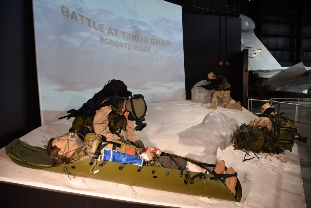
Enemy mortar rounds were falling closer to the area around the crashed helicopter, forcing the Rangers to relocate casualties. Several wounded men were placed in Skedco litters, flexible rescue stretchers built to move casualties across difficult terrain.
But the mountain resisted them.
The litters dragged against deep snow. The slope forced rescuers to work uphill. Beneath the snow, uneven ground shifted their footing as several men attempted to coordinate around a single casualty.
At one point, a litter began sliding downhill.
Men had to catch it before the wounded soldier disappeared down the steep slope.
The incident captured something that maps cannot easily communicate: gravity itself had become part of the evacuation problem.
Captain Self later described groups of four or five men moving wounded personnel distances of roughly eighty meters. The teams would carry or drag a casualty uphill, stop to recover, then continue.
Altitude compounded exhaustion, snow compounded weight and the incline compounded both.
Eighty meters in ordinary life might take less than a minute to walk.
On Takur Ghar, moving one wounded man that distance could require ten or fifteen minutes.
And there were several wounded men who all deserved to return home.
Self began rotating his men through the work. Some held defensive positions. Others moved casualties. Men who could briefly step away rested before returning to one of the two.
By then, many had gone through the night with little or no sleep. Their clothing was soaked by snow and cold. Their bodies had spent hours fighting, climbing, carrying, and working in thin air.
Still, there was no way around the mountain.
The wounded simply would not be left where they were, and the terrain offered no easier route.
So they continued forward, one exhausting stretch at a time.
Holding Roberts Ridge
The battle continued through the morning and into the afternoon.
Overhead, American aircraft attacked enemy positions around the summit. On the ground, Rangers and other special operators continued defending the high ground.
Even airpower was constrained by geography. Friendly and enemy positions were close enough together that strikes required tremendous precision, and some explosions landed near enough to American positions to send debris across them.
The mountain concentrated everyone into a relatively small battlefield.
Meanwhile, the cold continued its slow work.
Movement generates heat, but wounded men cannot keep moving. As casualties remained exposed on a snow-covered mountain at high altitude, maintaining body temperature became another part of keeping them alive.
Sleeping bags, clothing, and other supplies were pulled from the wrecked aircraft and placed around the wounded.
Among those treating them was Air Force pararescueman Senior Airman Jason Cunningham. Pararescuemen are trained to reach injured service members in places where ordinary evacuation becomes impossible, and Takur Ghar had become exactly that kind of place.
Cunningham moved between the wounded while the battle continued around him.
He was eventually shot and mortally wounded.
Even after being hit, he continued helping direct care for the other casualties. His actions were later credited with saving multiple lives, and he was posthumously awarded the Air Force Cross.
As afternoon began moving toward evening, the mountain imposed one more delay. Extraction could not safely occur until later.
There was no road convoy coming to the summit. No vehicle could simply drive up and carry the wounded away. Helicopters remained the only practical way to remove the force, and until conditions allowed them to return safely, the Americans had to stay where they were.
They watched the surrounding ridges as the temperature fell and daylight began to disappear.
Until darkness came, Takur Ghar had to be held.

Seventeen Hours
Helicopters finally returned after nightfall.
By then, the Americans on Takur Ghar had spent much of the day fighting, climbing, carrying casualties, treating the wounded, and enduring the cold at high altitude.
What began in darkness as a reconnaissance mission had stretched into roughly seventeen hours of combat.
Seven Americans were killed:
Petty Officer First Class Neil Roberts.
Technical Sergeant John Chapman.
Sergeant Philip Svitak.
Private First Class Matthew Commons.
Sergeant Bradley Crose.
Specialist Marc Anderson.
Senior Airman Jason Cunningham.
Twelve others were wounded.

The survivors, the injured, and the fallen were finally lifted away from the summit after nightfall.
Below them, the Shah-i-Khot Valley once again disappeared into darkness. Takur Ghar remained where it had always been. A cold, steep piece of high ground rising above the valley, indifferent to the lives that had been fought for across it.
But to the Americans who had spent that day there, it would never again be only a mountain.
Takur Ghar entered American military history under another name.
Roberts Ridge.

No Easy Ground
Military history often becomes surprisingly flat once it reaches a page.
Mountains become contour lines. Snow becomes a weather condition. A climb becomes an elevation gain. A casualty evacuation becomes a distance measured in meters.
Those numbers are necessary, but they can obscure the thing that mattered most to the people who were actually there: the physical experience of moving through the environment.
Ten thousand feet is only a number until someone has to breathe there.
Three feet of snow is only a measurement until every step has to be pulled through it.
A thousand feet of elevation is only a line on a map until a Ranger has to climb it carrying armor, ammunition, a rifle, and everything needed to fight when he reaches the top.
Eighty meters seems insignificant until a wounded man is lying in a litter and four exhausted soldiers have to drag him uphill across snow-covered ground.
Takur Ghar is remembered because of the men who fought there, and rightly so. But the battle also demonstrates something that has remained true across centuries of warfare:
Terrain matters.
Mountains determine what can be seen and what remains hidden. Valleys funnel movement. Snow slows the body and covers the ground beneath it. Cold threatens men who can no longer move to generate warmth. Altitude quietly reduces endurance with every breath. Weather changes visibility, and steep slopes turn ordinary tasks into physical problems.
Even the most sophisticated equipment still has to operate inside that reality.
Technology changed what was possible, but it did not make the mountain’s unforgiving environment disappear.
Eventually, there were still Rangers standing thousands of feet below the men they needed to reach, looking up at a snow-covered slope with no road to follow and no shortcut available.
That reality sits close to the heart of the Ranger tradition: the ability to continue through terrain and conditions that refuse to cooperate, particularly when the original plan has already changed and the way forward must be found in real time.
What happens when the temperature drops?
When the ground becomes steeper?
When water, mud, dust, rock, snow, or distance begin working against you?
When something that appeared manageable on a map becomes far more demanding once you are standing inside it?
That is when preparation matters.
That is when equipment matters.
And that is when reliability stops being an abstract quality and becomes something earned through use.
The Rangers who fought on Takur Ghar experienced those truths under circumstances few people will ever face. Their story belongs first and foremost to them, and to the seven Americans who did not leave the mountain alive.
But Roberts Ridge also leaves behind a broader reminder written into the landscape itself.
The world does not always offer easy ground.
Sometimes the trail disappears beneath snow. Sometimes the air grows thin. Sometimes the weather changes, the route becomes harder, and the distance ahead feels very different from the one that appeared on the map.
The mountain does not adjust itself for the person crossing it.
You adjust to the mountain. And you keep moving.
